Mountain Hiking in East Africa
Mountain hiking in East Africa is an unparalleled adventure that unfolds in the heart of three captivating nations: Uganda, Kenya, and Tanzania. These countries boast some of the most iconic and dramatic mountain ranges on the continent, each with its unique allure. In Uganda, the Rwenzori Mountains offer challenging treks through lush rainforests and glacier-capped peaks. Kenya’s Mount Kenya stands as Africa’s second-highest summit, with diverse landscapes and rich wildlife encounters. Meanwhile, Tanzania’s Mount Kilimanjaro reigns as the continent’s highest peak, offering awe-inspiring vistas and diverse ecosystems. Whether you’re a seasoned trekker seeking new heights or a nature enthusiast looking to explore the wonders of East Africa, these mountains promise unforgettable journeys, cultural insights, and a deep connection with the rugged beauty of the region.
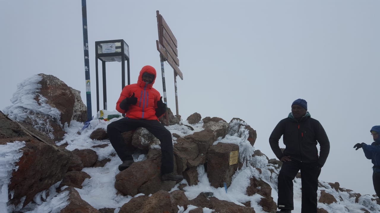
Mountain Kilimanjaro.
Dominating the landscape like no other mountain, iconic and instantly recognizable, Kilimanjaro in Tanzania is the highest peak in Africa and the world’s tallest free standing mountain at 5895 meters. To climb Kilimanjaro is a great challenge and entirely feasible for the active traveler or keen walker looking for something new. In a matter of days, you’ll climb Kilimanjaro from the hot plains of Africa through grasslands, tropical rain forest, alpine meadows, moorlands and desert uplands onto snow and ice.
As one of the premier Mount Kilimanjaro tour operators, we have regular climbs on four of the main routes:
- Trekking Mount Kilimanjaro via the Machame route in 7 days is our preferred route as it offers excellent acclimatisation and views.
- The Lemosho route, is the same as the Machame route after the second camp (Shira Plateau), but gives an extra day on the mountain.
- Or there is the Rongai route which approaches from the north of the mountain and is a less travelled option. It’s also good during the rainy season as it’s more sheltered.
- Or for those who have a bit of time we also have climbs via the 9-day Northern Circuit route.
We are Experienced Kilimanjaro Tour Operators
We’re a company run by mountaineers so you’ll find safe itineraries, safety measures and training for all our staff. Our office crew are outdoors people with a wealth of experience on Kilimanjaro, and they also remember what it’s like to dream of a climb to the roof of Africa! They can answer your questions and help put the whole trip into perspective. So don’t be afraid to call us for a chat or drop us an email (info@umarellavoyagesafaris.com) with any questions.
Facts About Kilimanjaro
Kilimanjaro in Tanzania is the highest peak in Africa and the highest free-standing mountain in the world. At 5895 meters, to climb Kilimanjaro is a great challenge, not to be underestimated, but entirely feasible for the hill walker looking to combine a high mountain adventure with going to Africa.
Kilimanjaro translates to “mountain of the springs” and its unique position just below the equator offers an opportunity to experience five different habitats from bottom to top, which makes an ascent of the mountain undeniably special. In a matter of days, you’ll climb Kilimanjaro from the equator to what feels like the Arctic, moving through grasslands, tropical rainforest, alpine meadows, moorlands and desert uplands to snow and ice.
Best Time to Climb Kilimanjaro
The main seasons are traditionally December to Mid-March and June to October with temperatures in Moshi averaging 22 degrees C and summit temperatures around – 7 degrees C. The rains are in April, May and November but nowadays climate change has changed this pattern so sometimes the rains come earlier or later. During the rains we run our Rongai climbs as the northern side of the mountain is more sheltered.

Mountain Rwenzori.
Previously referred to as the ‘Rwenzori Range,’ the Rwenzori Mountains are a mountain range situated in Eastern Equatorial Africa. They are along the border between DRC and Uganda. In addition to supporting glaciers, these mountains are among the sources of the famous Nile River.
The Rwenzori Range became part of the famous Rwenzori Mountains’ National Park back in 1991. This park covers approximately 996 square kilometers of rugged mountain terrain. In 1994, it was proclaimed as a UNESCO World-Heritage Site to protect the area’s flora and fauna and its overall natural beauty.
Facts at a Glance
Length: 120 Kilometers (75 Miles)
Width: 65 Kilometers (40 Miles)
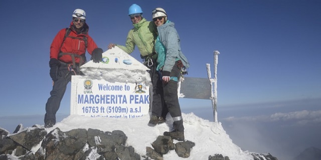
Highest Peak(s): Margherita Peak at 5.11 Kilometers (16,762 Feet)
Country: Uganda, DRC
Hiking the Rwenzori Mountains
If you love hiking, then you’ll undoubtedly want to consider the 5,119 meters-high, snow-capped ‘Mountains of the Moon.’ They offer just the unique trekking and hiking experiences you’ve likely been looking forward to.
The Rwenzori Central Circuit Zone offers plenty of opportunities for nature walk Such include walks through the Kichamba communities to the Karangura Ridge, trails up to the Buraro Chimp Forest and Lake Mahoma, and hiking through Bwamba Pass to the Bundibugo area.
The Bwamba Pass is a 1,500-metre high trek atop the steep Northern Rwenzori Ridge. Here, the Abanya community will lead you over the mountains and isolated villages to reach the Bamboo Forest. From this point, you’ll be able to enjoy superb views of the Rift Valley.
The communities of Turaco and Ruboni offer opportunities for guided forest walks just outside the Rwenzori Mountains National Park. You can follow the iconic River Mubuku and enjoy Fort Baker & Portal Peaks’ scenic views as you hike up to around 2,300 meters above sea level.Mountain Hiking in East Africa
It’s even possible to enjoy truly spectacular views of the highest, snow-capped Margherita Peak on clear days. Additionally, you’ll want to keep your eyes open for birds, vervet monkeys, squirrels, and chameleons.
Rwenzori Mountains’ Highest Peaks
By the early twentieth century, the Rwenzori Mountain Range was still hugely unexplored and its peaks unclimbed. During then, Uganda was a large region filled with dense forests, malaria-infested swamps, and lakes. Luigi Di Savoia, an ancient Duke of Abruzzi, began pondering about climbing the Rwenzori Mountains.
Luigi had previously reached the highest peaks of Mount Saint Elias (Alaska). He departed for Uganda with his scientific expedition in 1906, accompanied by J. Brocherel, C. Ollier, and J. Petigax. He was able to reach the loftiest peak, climbing 5,109 meters high. Luigi di Savoia named this peak ‘Margherita’ after an Italian Queen who had financed his expedition. Mountain Hiking in East Africa
Rwenzori Mountains weather seasons
The region is around the Equator and, consequently, doesn’t experience summer and winter weather extremes. It remains attractive throughout the year, despite the change in seasons. It barely causes any significant changes to the range’s fauna and flora.
The Rwenzori Mountain Range has two wet seasons and two short dry seasons. The long wet season starts in March and ends in June, while the short wet season occurs in November. During the wet season, the mist masks the Rwenzori Peaks. Although that helps form snow caps and glaciers at the higher summits, it can also make route-finding and hiking considerably tricky.
Best time to the Rwenzori
One of the dry seasons begins in July and ends in October, while the other falls between December and February. These are the best times to go to the Rwenzoris as they are the driest and warmest months. However, you can ideally expect some rains in such times, although they occur less frequently and often at night.
Bear in mind that the climate around the Rwenzori is unpredictable. The periods discussed earlier may vary from a year to another. At times, the rains may come early or come late. They may be mild or torrential.
All hikers should experience the Rwenzori Mountains. The hiking is incredible, the wildlife is amazing, it is an all-around thrilling experience.
Mountain hiking in Kenya
Kenya is a country beloved by many people in the world. It is the eyes of east Africa, and this gem sits at the center of the equator; therefore, the climatic conditions are quite favorable for hiking throughout the year. There are amazing hiking places in Kenya waiting to be explored. Some of the hiking trails in Kenya are marked out, while others are not. However, the thrill of summiting these mountains while hiking is something that you should not miss.
When planning to go and hike in the rift, the central or the southern part of the country, you must check the prevailing weather conditions in these locations. The highland areas usually experience heavy rains from April until August. However, in the lowland areas, heavy rains are restricted to just April and May. However, you can hike the mountains any time of the year.
Why You Should Explore Hiking Places in Kenya
Kenya enjoys a relatively tropical climate; therefore, you will find that the temperatures are warm most times of the year. The variation of altitude is perfect for hiking as it creates easy to moderate hiking trails. You will find lower mountains with relatively low elevation and high peaks, such as Mount Kenya and Mount Elgon, at high elevation. The routes usually have low bushes and grasslands, and you will find the cattle grazing in the highlands as you hike. Besides, you can choose to set up a camp high in the mountains for you to enjoy the sunset and sunrise as well as the picturesque undulating mountain range.
Higher up the mountains, the temperatures can go low, and you should be well prepared to deal with the prevailing condition. You should have proper hiking boots, a decent rain jacket, warm clothing as well as gloves. Guides are usually unnecessary, but if you want to walk with local guides, this could be a chance to explore more areas as there can be areas where the trail is not marked well. There are numerous locations that you will enjoy hiking in the country
Hiking Mount Kenya
Mount Kenya is the second-highest mountain in Africa, following Mount Kilimanjaro. It is one of the most challenging mountains to summit because it is pretty steep, and the terrain can be slippery when it rains heavily. However, this does not deter people as many have summited this mountain several times, and they still go back. Climbing this mountain will require you to get expert guidance. Mount Kenya national park has about thirty routes, and you can use the most popular routes to avoid confusion. The Chogoria route is more popular, and you can use this route for hiking to the mountain top.
The best time you can and hike Mount Kenya is from August to October. During this period, the rains have stopped, and the terrain is quite fair.
The hiking trail is classified as moderate; therefore, you would expect some areas to be challenging while others are summit able.
For all Mountain hiking in East Africa you need, we are a one stop shopping center.
Reach us on info@umarellavoyagesafaris.com, umarellavoyagesafaris@gmail.com, and all our social media platforms.